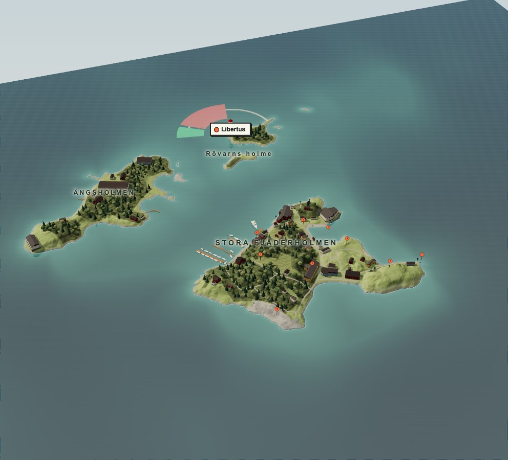
Stora Fjäderholmen, Ängsholmen, Libertas and Rövarns holme: four names to get to know in Saltsjön. Start with the whole table, then zoom in until the places become possibilities.
Turn the islands around, follow the shore or head straight for a place that catches your eye. The field guide has the kitchens, studios and boats to look for ashore.
02 / ARRIVING BY BOAT
The commute is the point.
Fjäderholmslinjen and Strömma arrive at Stora Kajen on the north shore. Waxholmsbolaget uses Ångbåtsbryggan at the southeast tip. Check your operator’s quay and last boat home, then leave the crossing free for looking out of the window.
03 / SINCE 1381
Spirits, shells and a reopening.
First recorded in 1381, the islands later played a part in L.O. Smith’s nineteenth-century spirits war with Stockholm. The navy arrived in the 1920s; military use followed.
After restoration under Kungliga Djurgårdens förvaltning, they reopened to the public in 1985. A rather different kind of shore leave.
Stora Fjäderholmen has plenty of reasons to leave the galley alone: Fjäderholmarnas Krog, Rökeriet, Röda Villan, Systrarna Degens and Fjäderholmarnas Bryggeri. The Bryggeri’s island venue is a brewpub; production is in Bro. Find each venue, its own website and practical details in the field guide.
Opening times move with the season. Check the island’s own site before you plan lunch around it.
05 / AROUND THE ISLAND
Nine places, one small island.
Ångbåtsbryggan, the steamboat jetty
Grönborg
Hantverksbyn, the crafts village
Festplatsen
Krogviken
Torget
Trädgården
Stora Kajen
Solklipporna, the sunny rocks
Pick a place and follow the island paths. The numbers here help you find the field notes; they are our own, separate from the official guide’s business and service numbers.
06 / ALLMOGEBÅTARNA
Boats that built the archipelago.
Visit Allmogebåtarna, the exhibition of traditional boats. Then look for the information boards “Stenbrott och konst” and “Skärgårdsvik” as you continue around the island.
07 / LIBERTUS
A light that counts to three.
Libertus, on the islet of Libertas, flashes three times every nine seconds: Fl(3) 9s. Watch for the rhythm at dusk: three flashes, then a pause.
1PUNI / THE SHORE-LEAVE FIELD GUIDE
Shore leave. Properly considered.
Kitchens, craft studios, old boats and nine places to explore ashore. Pick a place to start; lunch can decide the rest.
THE ISLAND AT A GLANCE
Arrive
By passenger ferry or your own boat. Check the operator or guest-harbour office before setting off.
Go ashore
Explore Stora Fjäderholmen on foot. For step-free access, check with your ferry operator and the places you plan to visit.
Choose your season
Check each venue’s website for seasonal opening times before setting off.
Leave lightly
Respect closed areas and take sortable rubbish back to the mainland, as the island’s management asks.
Visitor guidance: Kungliga slotten. This is a shore guide, not a pilot book.
Harbour & ferry
Harbour & ferry
Gästbryggorna · Guest piers
The two guest piers sit on Stora Fjäderholmen’s northwest shore, between the fuel jetty and Stora Kajen. Contact the harbour office for a berth.
What
Two guest mooring piers
From the harbour
On the northwest shore, beside the guest-harbour office.
Harbour office · 08-716 39 10
Sources
Local guidance · guest-pier designation, 30 September 2026
Checked 2026-09-30. Declared geographic anchor: guest_piers; Guest-berth designation follows local guidance supplied 2026-09-30: the two northwestern mooring piers of Stora Fjäderholmen. Exact footprints are OSM ways 118316337 and 118316335, both tagged man_made=pier, floating=yes, mooring=yes in the receipted extract. The farther-west fuel jetty way/25166617 is mooring=no and is excluded. https://www.fjaderholmarna.se/ confirms Sjömacken & Gästhamnskontor (21), but does not identify individual guest piers. OSM mooring=yes supports mooring, not independently the guest designation. No berth availability or depth inferred. Guide label at the mean of the two footprint representative points; the highlights follow their actual mapped outlines..
Harbour & ferry
Sjömacken & gästhamnskontoret
The guest-harbour office and fuel station share the pier west of Stora Kajen. Contact the office about berthing.
Checked 2026-09-30. Declared geographic anchor: harbour_office; Office and fuel together: official KDF 2026 guide p.2 entry 21; fuel point https://www.openstreetmap.org/node/10951900819 at 59.3292339 N, 18.1729078 E. Source: https://www.kungligaslotten.se/download/18.16d82aa19d24cb639bac92/1774540689906/Fjaderholmsguiden_KDF_2026.pdf..
Harbour & ferry
Stora Kajen · Fjäderholmslinjen & Strömma
Fjäderholmslinjen and Strömma use Stora Kajen on the north shore. Waxholmsbolaget uses Ångbåtsbryggan at the southeast tip. Check your operator’s timetable and last boat home.
Checked 2026-09-30. Stora Kajen, north shore: representative point of mapped quay https://www.openstreetmap.org/way/164859726. Official KDF 2026 south-up map p.2 places boatlines 19 Strömma and 20 Fjäderholmslinjen here: https://www.kungligaslotten.se/download/18.16d82aa19d24cb639bac92/1774540689906/Fjaderholmsguiden_KDF_2026.pdf.; resolved from OSM way/164859726; final display offset from declared coordinate: 13.0 m.
Harbour & ferry
Ångbåtsbryggan · Waxholmsbolaget
Waxholmsbolaget lands at Ångbåtsbryggan on the southeast tip. For Fjäderholmslinjen or Strömma, use Stora Kajen on the north shore.
Checked 2026-09-30. Waxholmsbolaget at Ångbåtsbryggan, southeast quay. SL Transport API site 952 (59.327535 N, 18.179603 E), recorded in the verified 2026-09-29 research handoff and cross-checked against OSM node/14047315491, NeTEx SE:001:Quay:9022001000952001; official KDF 2026 guide p.2 boatline 1. Sources: https://www.openstreetmap.org/node/14047315491; https://www.kungligaslotten.se/download/18.16d82aa19d24cb639bac92/1774540689906/Fjaderholmsguiden_KDF_2026.pdf. Exact declared quay coordinate retained.; final display offset from declared coordinate: 0.0 m.
Eat & drink
Eat & drink
Fjäderholmarnas Krog
A proper island restaurant, with Hamnbaren alongside the main Krog. For the part of shore leave that involves sitting down and letting someone else handle lunch.
What
Restaurant & harbour bar
From the harbour
On Stora Fjäderholmen; continue on foot from the guest harbour.
Wood, textiles, ceramics, glass, metal and chocolate: the island’s craft studios give you plenty to browse. Book a workshop through Craft Island to try your hand.
What
Craft studios & workshops
From the harbour
On Stora Fjäderholmen; continue on foot from the guest harbour.
Checked 2026-09-30. Official KDF 2026 guide p.2, south-up map; named area at pixel [379, 352] in 1132×1600 page raster, four-anchor affine registration to EPSG:3006. Control RMS 13.13 m, max 20.36 m; independent checks up to 53 m, indicative area only (about 60 m uncertainty). Source: https://www.kungligaslotten.se/download/18.16d82aa19d24cb639bac92/1774540689906/Fjaderholmsguiden_KDF_2026.pdf; reproducible anchors and matrix: map-registration.json.; final display offset from declared coordinate: 0.0 m.
See & do
Allmogebåtarna
An exhibition of traditional boats. For anyone who has ever looked at a wooden hull and completely lost track of lunch.
What
Permanent boat exhibition
From the harbour
On Stora Fjäderholmen; continue on foot from the guest harbour.
Checked 2026-09-30. Waxholmsbolaget at Ångbåtsbryggan, southeast quay. SL Transport API site 952 (59.327535 N, 18.179603 E), recorded in the verified 2026-09-29 research handoff and cross-checked against OSM node/14047315491, NeTEx SE:001:Quay:9022001000952001; official KDF 2026 guide p.2 boatline 1. Sources: https://www.openstreetmap.org/node/14047315491; https://www.kungligaslotten.se/download/18.16d82aa19d24cb639bac92/1774540689906/Fjaderholmsguiden_KDF_2026.pdf. Exact declared quay coordinate retained.; final display offset from declared coordinate: 0.0 m.
PLACE / 02
Grönborg
Grönborg is the wooded southern part of the island above Ångbåtsbryggan.
Checked 2026-09-30. Official KDF 2026 guide p.2, south-up map; named area at pixel [250, 175] in 1132×1600 page raster, four-anchor affine registration to EPSG:3006. Control RMS 13.13 m, max 20.36 m; independent checks up to 53 m, indicative area only (about 60 m uncertainty). Source: https://www.kungligaslotten.se/download/18.16d82aa19d24cb639bac92/1774540689906/Fjaderholmsguiden_KDF_2026.pdf; reproducible anchors and matrix: map-registration.json.; final display offset from declared coordinate: 0.0 m.
PLACE / 04
Festplatsen
Festplatsen lies inland from Krogviken, beside the craft area.
Checked 2026-09-30. Official KDF 2026 guide p.2, south-up map; named area at pixel [214, 360] in 1132×1600 page raster, four-anchor affine registration to EPSG:3006. Control RMS 13.13 m, max 20.36 m; independent checks up to 53 m, indicative area only (about 60 m uncertainty). Source: https://www.kungligaslotten.se/download/18.16d82aa19d24cb639bac92/1774540689906/Fjaderholmsguiden_KDF_2026.pdf; reproducible anchors and matrix: map-registration.json.; final display offset from declared coordinate: 0.0 m.
PLACE / 05
Krogviken
Pause by Krogviken for a look across the bay before continuing around the island.
What
Bay · view from shore
From the harbour
On Stora Fjäderholmen; continue on foot from the guest harbour.
Checked 2026-09-30. Krogviken bay point from https://www.openstreetmap.org/node/1764542853; bay identity cross-checked on the south-up official KDF 2026 map p.2: https://www.kungligaslotten.se/download/18.16d82aa19d24cb639bac92/1774540689906/Fjaderholmsguiden_KDF_2026.pdf.; resolved from OSM node/1764542853; final display offset from declared coordinate: 0.0 m.
PLACE / 06
Torget
Pause at Torget as you make your way between Krogviken and the north harbour.
What
Square
From the harbour
Just inland from the north harbour, near Systrarna Degens stuga.
Checked 2026-09-30. Official KDF 2026 guide p.2, south-up map; named area at pixel [214, 530] in 1132×1600 page raster, four-anchor affine registration to EPSG:3006. Control RMS 13.13 m, max 20.36 m; independent checks up to 53 m, indicative area only (about 60 m uncertainty). Source: https://www.kungligaslotten.se/download/18.16d82aa19d24cb639bac92/1774540689906/Fjaderholmsguiden_KDF_2026.pdf; reproducible anchors and matrix: map-registration.json.; final display offset from declared coordinate: 0.0 m.
PLACE / 07
Trädgården
Trädgården is the garden area shown inland from Röda Villan, with the boule courts nearby.
What
Garden area
From the harbour
Inland from Röda Villan on the western side of the island.
Checked 2026-09-30. Official KDF 2026 guide p.2, south-up map; named area at pixel [449, 487] in 1132×1600 page raster, four-anchor affine registration to EPSG:3006. Control RMS 13.13 m, max 20.36 m; independent checks up to 53 m, indicative area only (about 60 m uncertainty). Source: https://www.kungligaslotten.se/download/18.16d82aa19d24cb639bac92/1774540689906/Fjaderholmsguiden_KDF_2026.pdf; reproducible anchors and matrix: map-registration.json.; final display offset from declared coordinate: 0.0 m.
PLACE / 08
Stora Kajen
Stora Kajen is the north-shore landing for Fjäderholmslinjen and Strömma. Check your operator before choosing your quay.
Checked 2026-09-30. Stora Kajen, north shore: representative point of mapped quay https://www.openstreetmap.org/way/164859726. Official KDF 2026 south-up map p.2 places boatlines 19 Strömma and 20 Fjäderholmslinjen here: https://www.kungligaslotten.se/download/18.16d82aa19d24cb639bac92/1774540689906/Fjaderholmsguiden_KDF_2026.pdf.; resolved from OSM way/164859726; final display offset from declared coordinate: 13.0 m.
PLACE / 09
Solklipporna
Head to Solklipporna on the southwest shore for sun-warmed rock and a view across Saltsjön.
What
Rocky shore & viewpoint
From the harbour
On the southwest shore; follow the island paths from the harbour.
Checked 2026-09-30. Solklipporna named locality on southwest shore from https://www.openstreetmap.org/node/8898660240, confirmed visually in official KDF 2026 south-up map p.2: https://www.kungligaslotten.se/download/18.16d82aa19d24cb639bac92/1774540689906/Fjaderholmsguiden_KDF_2026.pdf.; resolved from OSM node/8898660240; final display offset from declared coordinate: 0.0 m.
History
History
Stenbrott och konst
Look for the information board “Stenbrott och konst” — “Quarry and art” — during your walk.
What
Information board
From the harbour
On Stora Fjäderholmen; continue on foot from the guest harbour.
The coastline and building footprints follow OpenStreetMap. Elevation and seabed data give the islands their shape. Sources and downloadable data are below.
Seabed: EMODnet Bathymetry Consortium, EMODnet Digital Bathymetry (DTM), CC BY 4.0. Close inshore the depths are shaped to the mapped coastline: illustrative, not measured. The illustrated shore slope is not an approach survey.
Sea chart:OpenSeaMap marine data and OpenStreetMap geometry, drawn in OpenHelm’s chart style. The regional depth layer uses EMODnet; it does not provide nearshore soundings. Data and tile licences.
Illustrations: The shore-leave still life is original generated artwork. The nine place numbers are editorial labels, not an official walking route. Named areas without mapped coordinates are located approximately from the official south-up visitor map; registration details are in each entry’s Sources. Buildings keep mapped footprints; unrecorded roofs, window layouts, colours and individual trees are interpretations, not surveyed details. Heights are exaggerated 1.25 times. Buildings use level floors and foundation skirts over the ground model; unrecorded architectural details remain illustrative. The traditional wooden boat is an original model inspired by Jonas Borg’s photograph on fjaderholmarna.se; its dimensions and berth are illustrative. The animated ferry route is fictional. Rendering by three.js (MIT, licence).
Take the chart home: scene.json (ODbL 1.0) · terrain.bin (Int16 decimetres, north first) · LINEAGE.json (every input’s URL, hash and licence)
NOT FOR NAVIGATION. Depths near shore are modelled. The light sectors are shortened. The animated ferry route is fictional.