MALMA KVARN · MALMAÖN · KORSHAMN / STOCKHOLM ARCHIPELAGO
The sea chart got up off the table.
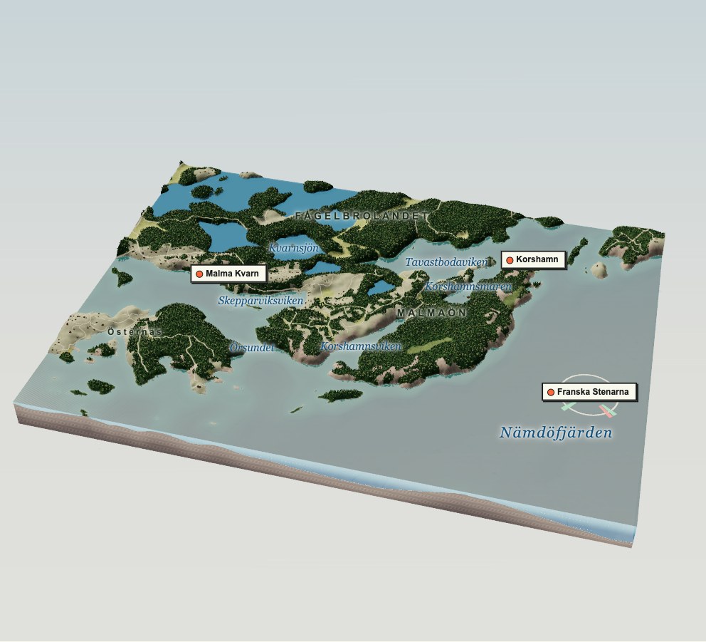
Fourteen square kilometres of the Stockholm archipelago, built into a table-top model from open elevation, seabed and map data. There’s a harbour with a sauna, a watermill that stopped, a beaver with plans, a glacier’s potholes and a lighthouse that talks in colours.
Turn it, zoom it, or scroll the story and it’ll fly you round. Not for navigation. Not even slightly.
Unfolding the chart…
Drag to turn · scroll or pinch to zoom · right-drag or two fingers to slide · keys 1–7 jump
Follow the shore from Malma Kvarn’s harbour to the glacial potholes at Korshamn. Between them lie wooded slopes, sheltered bays and the narrow connections that once separated these islands.
Turn the landscape around, zoom into a bay or choose one of the stops below. You can also raise the sea to explore how a different waterline changes the coast.
02 / MALMA KVARN
A harbour with a business plan.
The Swedish Cruising Club has kept a harbour at Malma Kvarn since 1946. There’s a wood-fired sauna, a kiosk and a summer bistro. Check with the club for guest berths and seasonal opening times.
A harbour with a sauna is a business. Add a bistro and it’s a strategy. The burgundy ketch with the yellow pennant in the bay is Nike, 1puni’s headquarters, at anchor for a little shore leave.
Kvarn means mill. A stream runs out of Kvarnsjön, past the ruin of a watermill in Sweden’s heritage register (L2013:6746), and down into the bay the harbour is named after. The miller is long gone. The ghost wheel is ours; the stones are real.
04 / KORSHAMNSMAREN
Meanwhile, an ambitious beaver.
Across the water in Korshamnsmaren lives an extremely ambitious beaver. It works alone, builds its own infrastructure and has strong opinions about water levels. We relate.
A mar is a shallow, sheltered archipelago bay, and land uplift is slowly turning many of them into lakes. Patience is part of the business plan.
Cookie spotted the beaver here in Korshamnsmaren.
05 / KORSHAMN
The glacier left the bath running.
At the end of the last ice age, whirlpools in the meltwater spun stones and gravel against the bedrock hard enough to drill deep kettles into it. The biggest in Korshamn is about six metres across.
The 1.3-hectare reserve on Malmaön’s northern tip has been protected since 1962. It’s pine and spruce. No fires. Leave the kettles exactly where the ice put them.
The light on Franska Stenarna flashes twice every six seconds. Look towards it from different directions and its colour changes between white, red and green.
Wait for dusk and watch the pair of flashes repeat across the water.
07 / THE LAND IS STILL RISING
Push the sea back up.
The ice didn’t just drill holes. It pressed the whole land down, and the land is still springing back, roughly half a metre a century around Stockholm. Fågelbrolandet is several former islands welded together this way, Malmaön among them.
Today. The land model measures treetops as well as rock, so in the model Malmaön only lets go at about +10 m. The history books say it joined the mainland within the last few centuries, so the real rock sits lower. Treat every date here as a rough guess.
WHERE THIS CAME FROM
Open data, with receipts.
The coastline and building footprints follow OpenStreetMap. Elevation and seabed data give the landscape its shape. Sources and downloadable data are below.
Seabed: EMODnet Bathymetry Consortium, EMODnet Digital Bathymetry (DTM), CC BY 4.0. Its grid is about 115 m, so close inshore the depths are shaped to the mapped coastline: illustrative, not measured. Depth figures are printed only where the grid itself sets the depth. Real soundings in Swedish waters can’t be published without a spreading permit from Sjöfartsverket.
Rendering:three.js (MIT, licence). Building footprints follow the map; unrecorded roofs, windows, colours and individual trees are interpretations. The boats, beaver, ghost wheel and kettles are illustrative; the lodge follows Cookie’s sighting. Heights are exaggerated 2.5 times, and light sectors are shortened. Depth figures are grid averages, not surveyed soundings.
Take the chart home: scene.json (ODbL 1.0) · terrain.bin (Int16 decimetres, 440 × 325, north first) · LINEAGE.json (every input’s URL, hash and licence)
NOT FOR NAVIGATION. Depths near shore are modelled. The light sectors are shortened. The beaver is not to scale.